- [email protected]
- MON-SAT:8AM TO 9PM
 Sale!
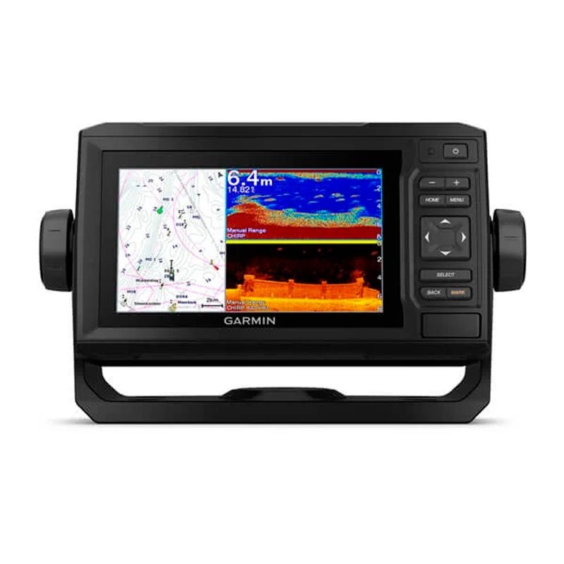
Sale! Garmin EchoMAP UHD 62cv, with GT24 xdcr transducer
$100.00
$783.00
Description of the Garmin EchoMAP UHD 62cv fishfinder, with GT24 xdcr transducer:
The 6 sunlight-readable display and key plotter features a quick-release surface-mount bracket. Plus, the Transducer Pack adds HD scanning sonar and CHIRP traditional sonar.
GT24-TM TRANSDUCER
Enjoy high-definition ClearV scanning sonar, giving you a crystal-clear image of what’s just below your boat. Plus, you get Garmin’s high-frequency band CHIRP traditional sonar, which provides exceptional target separation.
OPTIONAL CHARTS AND MAPS
Enjoy unmatched coverage and detail with compatibility with BlueChart g3 Vision marine charts, which feature built-in Garmin and Navionics content.
QUICKDRAW CONTOURS
Create custom on-screen fishing maps with 30m contours. Keep the data to yourself or share it with the QuickDraw community on Garmin Connect.
NMEA 2000 AND NMEA 0183 NETWORKS
Access autopilots, digital switching, weather forecast, FUSION-Link audio system, multimedia content, VHF, AIS and much more on a single screen.
ACTIVECAPTAIN APP
Built-in Wi-Fi connectivity, allowing you to pair with the comprehensive free mobile app to access OneChart functionality, smart notifications1, software updates, Garmin QuickDraw community data and much more.
Physical and performance characteristics:
| UNIT DIMENSIONS (WIDTH/HEIGHT/DEPTH) | 21.8 x 13.0 x 6.2cm |
|---|---|
| SCREEN SIZE (WIDTH/HEIGHT) | 13.7 x 7.7cm; 15.2 cm (6.2″) diagonal |
| SCREEN RESOLUTION (WIDTH/HEIGHT) | 480 x 800 pixels |
| DISPLAY TYPE | WVGA display |
| WEIGHT | 0.7kg |
| WATER RESISTANCE CLASSIFICATION | IPX7 |
| MOUNTING OPTIONS | On surface or recessed |
| ENERGY CONSUMPTION | 12W |
| ANTENNA | Internal or external via NMEA 2000 |
| POTENCY OF TRANSMISSION | 500 W (RMS)/4000 W (peak-to-peak) |
| RECEIVER | 5hz |
| GARMIN MARINE NETWORK PORTS | None |
Maps and memory:
| PRE-INSTALLED MAPS | world basemap |
|---|---|
| ADMITS DATA CARDS | 1 microSD card; 32 GB maximum size |
| WAYPOINTS | 5000 |
| TRACKS | 50,000 points; 50 saved tracks |
| ROUTES | 100 |
Outdoor leisure functions:
- Tidal prediction.
Plotter functions:
- COMPATIBLE WITH GARMIN SOUNDER
- SUPPORTS AIS (TRACKS THE POSITION OF TARGET SHIPS)
- DSC SUPPORT (SENDS POSITION DATA TO DSC COMPATIBLE VHF)
- ACTIVECAPTAIN-YHTEENSOPIVA
Probe Specifications and Functions:
| COMPATIBLE WITH DOUBLE FREQUENCY PROBE | Yeah |
|---|---|
| COMPATIBLE WITH DUAL BEAM PROBE | Yeah |
| CLEARV | Yes, with CHIRP (built-in) |
| MAX DEEP |
700 meters at 77 kHz (in fresh water) 335 meters at 77 kHz (in salt water) (Maximum depth depends on bottom type and other water conditions) |
| BLOCK AT THE BOTTOM (SHOWS THE SIGNALS THAT IT RETURNS FROM THE BOTTOM TO THE SURFACE) | Yeah |
| CHART AND RECORD OF WATER TEMPERATURE | Yeah |
| PROBE RECORDING | Yeah |
| PROBE HISTORY BACK FUNCTION | Yeah |
Connections:
| COMPATIBLE WITH NMEA 2000 | Yeah |
|---|---|
| TRANSDUCER PIN NUMBERS | 4 |
| NMEA 0183 INPUT PORTS | 1 |
| NMEA 0183 OUTPUT PORTS | 1 |
| WIRELESS CONNECTIVITY | Yeah |
Shipping Info
Standard Shipping
Cost: $25
Free Shipping
We offer free shipping on orders over $30. Please check the free - shipping eligibility at checkout.
Delivery Time:
It usually takes [3-5] business days for standard shipping. Please note that this is an estimated time frame and may be affected by local holidays, and unforeseen circumstances.
Related products
Simrad Cruise-7 83/200
$98.00
$625.99
HOOK Reveal 5 with 83/200 HDI transducer & basemap
$99.00
$425.99
Reviews
There are no reviews yet.